@RespectTO on Twitter claimed that "Bloor has the worst rate for collisions in #biketo. Safe passage now. #topoli #BloorBikeLanes". They were rightfully celebrating the fact that we're one step closer to getting bike lanes on Bloor. Maybe I should have left well enough alone but I asked them: ".@RespectTO explain "worst". Gross numbers or per volume of cyclists compared to other streets?" It was an honest question but hard to explain intention in Twitter, thus my blog. How would we know Bloor Street is the worst and by what definition and measure? @RespectTO told me that it's according to City stats but they didn't have a link to share.
Let me just be clear that I'm quite happy that Bloor is getting this focus and deservedly getting bike lanes (hopefully) to help make people safer. But I think it's worth digging into this a bit. In the past I have dug up and analyzed statistics to help answer such questions, so let's do the same here.
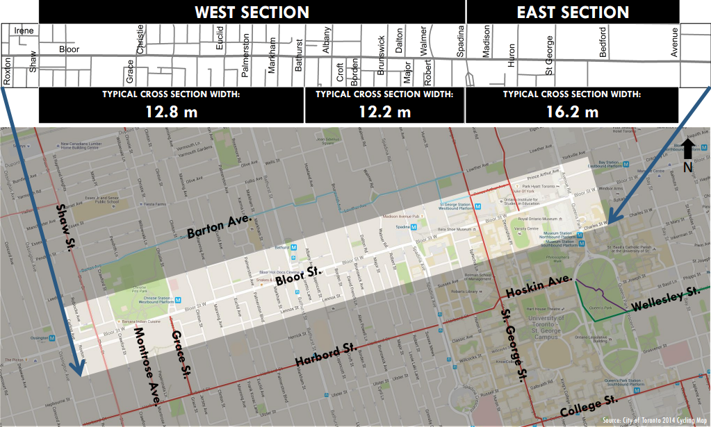
The claim: "Bloor is the worst for collisions". How can we make the claim testable? We'll need to compare Bloor Street to other streets, obviously, but we can't just use the entire lengths of streets because then we'd be comparing apples to oranges. We need equal measures. More importantly, the Bloor Street bike lanes pilot is only going from Shaw to Avenue so that's the only stretch that might become safer post-install. So let's compare the crash stats of Bloor from Shaw to Avenue to an equal length on an other street. I chose Queen St West, partly because it passes through the same cross streets as Bloor, going from Shaw to University, and because it's also a well-used route by people on bikes. (I could have also chosen Dundas, King or College for similar east-west streets.) Then I think if we just count all the collisions on Bloor and Queen along the same stretches we will know which one has had more collisions.
Note that there are also different ways to interpret "worst". In the gross sense, we might be focused on the total numbers of crashes and trying to reduce them. From the point of view of an individual person on a bike, however, the concern would be about the risk of a crash, that is, which street is more "dangerous". In this latter case, we're more concerned about the chance of a crash per person. And for that we'd need to divide our crashes by the volume of people cycling since that can be quite different depending on the street. But this will be too much work and it wasn't the original claim, so I'm just going to focus on the gross numbers.
The closest we have to crash stats by location is this map from a few years ago produced by the Globe and Mail, mapping out all collisions from 1985 to 2010.
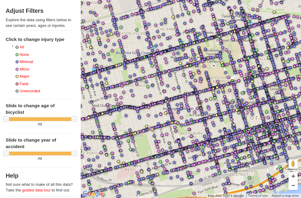
So I just started counting the dots and this is what I got:
Total collisions on Bloor Street, Shaw to Avenue: 261 collisons. 1 fatal, 14 major injuries (1985-2010)
Total collisions on Queen Street West, Shaw to University: 308 collisions. 1 fatal, 19 major injuries (1985-2010)
So Bloor and Queen are pretty close with Queen just edging out Bloor. We can speculate to why: maybe the average cycling volumes on Queen are a bit higher? Or maybe the streetcar tracks make Queen a bit more dangerous? We can't really know unless we have more data.
I'd actually like to see if the numbers on Queen have dropped since the protected bike lanes on Richmond and Adelaide were installed, creating a continuous route from Shaw to University (and beyond). With people going to those alternative routes the volumes on Queen have dropped and hopefully the overall crashes. And I hope the same happens on Bloor.
At any rate, I think we can conclude that the original claim by @RespectTO might have been true at some point (though I'm not sure) but it doesn't seem to be true anymore. But I will celebrate with them that we're finally getting bike lanes on Bloor.
[Update: I decided to count College Street between Shaw and University and came up with 259 collisions. 0 fatalities, 11 major injuries from 1985 to 2010. There are painted bike lanes along about 2/3s of the stretch, no physical separation. I believe the bike lanes have been there for the whole period, I'm not certain. It's not a surprise that College numbers are this high since it is also the busiest street for bike traffic. So if the City is serious about reducing collisions they could upgrade College. A painted bike lane is obviously not enough.]