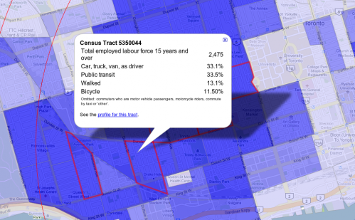
The map geeks at the Toronto star have outdone themselves with this google map of Commuter cyclists by census tract (a small area as defined by Statistics Canada's census). It shows the breakdown of how people commute who live in that area. The census tracts with red boundaries are over 10%.
Politicians need to stop treating cyclists as if they are marginal. If you lived in an area with cycling at 13% and showed this data to your councillor maybe a lightbulb would go off in their head. It's still a minority but not one they can always safely ignore.
It doesn't address who commutes through the area. For instance, the area southwest of Dundas West and Dufferin has 11.5% of commutes by bicycle, yet there may be many people driving through from the suburbs which will water down that percentage on the road.
The highest percentage is on the Toronto Islands at 29%. This is unsurprising, since no cars are allowed. It's odd to think that 18% of them still drive to work - they must be parking cars downtown.
The second highest is in Parkdale at 14%! This area bounded by Dundas, Queen, Sorauren and Lansdowne has an above the Toronto average household income and is mostly detached houses with a few condos.
The core of the highest rates of bike commuting is in the Annex - bounded by Bloor, Dovercourt, Spadina and Dundas. Leslieville and East York aren't too far behind.
King and Spadina has very few cycling commuters for downtown, but is packed full of condos. Over 40% of the people walk to work!
The two poorer parts of downtown, St. Jamestown and Regent park have low cycling rates of 3%, but really high transit rates of 60% (except for the part of Regent Park that is south of Dundas which has more cyclists at 8%.
What if 10% of the transportation budget was allocated to cycling in these dark blue areas? By now we'd likely see covered elevated tubes for us to cycle in.

Comments
Kevin Love
Actually, the second highest is 17.1%
Fri, 01/08/2010 - 21:01I see census tract 5350059, to the west of U of T, has 17.1% cycle commuters.
herb
right
Sat, 01/09/2010 - 13:15You're absolutely correct, Kevin. I don't know what I was smoking!
Rich Lafferty (not verified)
That's a weird Annex you've
Mon, 01/11/2010 - 00:50That's a weird Annex you've got there. Usually the Annex has Bloor (or maybe Harbord) as its south boundary, Davenport north, St George or so east, Bathurst or Christie west. Kensington and Chinatown aren't in the Annex, but U of T is. Dovercourt's in Bloorcourt Village, with Christie Pits and Seaton Village in between.
herb
point taken
Tue, 01/12/2010 - 19:19Other than Kensington, I'm not sure what that area is called: Little Portugal? Little Italy? That's becoming less true. Maybe I should just stick to what the city calls it: West End, though even that goes from Bathurst to Keele.
Dundas (not verified)
What's it called? Beaconsfield Village
Tue, 01/12/2010 - 20:40At least that's what the real estate folks call it. It's got a lot of "ladder streets" - short one-way residential streets connected by longer one-way streets, so is a bit of a pain to get around in by car (at least legally - you see a lot of wrong-way drivers.) You see a lot of wrong-way cyclists too but I think I'll let that slip.
It encompasses both Gladstone and Beaconsfield (Disraeli was Earl of Beaconsfield) so has two British Prime Ministers in it.
Dylan Passmore (not verified)
DAs
Fri, 02/12/2010 - 17:43Nice post Herb ... just came across it a bit late. I've been wanting to do a similar one myself for quite a while. I made me curious and I started looking at the smaller dissemination areas... several in Toronto are between 20% - 30% bike mode share. Also interesting to see how much things have changed since 2001.... that UofT CT, for example, was only at 6% in 2001 and the Parkdale CT was at 5%.
cheers